Excerpts from
Expert Judgement on Markers to Deter Inadvertent Human Intrusion into the Waste Isolation Pilot
Plant
(Sandia National Laboratories report SAND92-1382 / UC-721, p. F-49)
Team A:
Dieter G. Ast (Cornell University)
Michael Brill (Buffalo Organization for Social and Technological
Innovation, Inc.)
Ward Goodenough (University of Pennsylvania)
Maureen Kaplan (Eastern Research Group, Inc.)
Frederick Newmeyer (Univeristy of Washington)
Woodruff Sullivan (University of Washington)
Team B:
Victor R. Baker (University of Arizona)
Frank R. Drake (University of California at Santa Cruz)
Ben R. Finney (University of Hawaii at Manoa)
David B. Givens (American Anthropological Association)
Jon Lomberg (independent artist, designer, and writer)
Louis Narens (University of California at Irvine)
Wendell Williams (Case Western Reserve University)
Contents
- Executive Summary
- 2. The Problem of Message
- 2.1 Message Definition
- 4. Criteria for a Marking System with Examples
- 4.1 Site Design Guidelines for a Design of the Entire Site, so it is a Major Component of a System of Messages
- 4.2 Design Options
- 5. Conclusions
- 5.2 The Enormity of Marking the WIPP Site
- 5.3 Personal Thoughts
- 5.6"Beauty is conserved, ugliness discarded"
- See Also
Executive Summary
Sandia National Laboratories charged a panel of outside experts with the task to design a 10,000-year marking system for the WIPP (Waste Isolation Pilot Plant) site, and estimate the efficacy of the system against various types of intrusion. The goal of the marking system is to deter inadvertent human interference with the site. The panel of experts was divided into two teams. This is the report of the A Team; a multidisciplinary group with an anthropologist (who is at home with different, but contemporary, cultures), an astronomer (who searches for extra-terrestrial intelligence), an archaeologist (who is at home with cultures that differ in both time and space from our own), an environmental designer (who studies how people perceive and react to a landscape and the buildings within them), a linguist (who studies how languages change with time), and a materials scientist (who knows the options available to us for implementing our marking system concepts). The report is a team effort. There is much consensus on the design criteria and necessary components of the marking system. Understandably, there is some divesity of opinion on some matters, and this is evident in the text.
We developed the following criteria for the marking system:
The site must be marked. Aside from the legal requirement, the site will be indelibly imprinted by the human activity associated with waste disposal. We must complete the process by explaining what has been done and why.
The site must be marked in such a manner that its purpose cannot be mistaken.
Other nuclear waste disposal sites must be marked in a similar manner within the U.S. and preferably world-wide.
A marking system must be utilized. By this we mean that components of the marking system relate to one another is such a way that the whole is more than the sum of its parts.
Redundancy must play a preeminent role in the marking system design. The designs considered here have redundancy in terms of message levels, marking system components, materials, and modes of communication.
Each component of the marking system should be made of material(s) with little intrinsic value. The destructive (or recycling) nature of people will pose a serious threat to the marking system.
The components of the marking system should be tested during the next few decades while the WIPP is in operation, not only for the longevity of the materials but for the pan-cultural nature of the message. In other words, as with the repository design itself, the team was comfortable with the thought of designing a marking system that would last 10,000 years if left undisturbed. Our efforts focused on making it understandable while providing minimal incentive to disturb it. We also consider a public information effort a necessary part of the marking system design. A system that is not understood today has no chance of being understood in the far future.
Figures 4.3-1 through 4.3-18 provide a basic description of our most developed design and other design options
The central area of interest is surrounded by earthen berms. For the WIPP site, the area of interest is where we do not want drilling or excavation to occur. In the design the central area is the area of the underground panels plus either
- a one-fourth-mile buffer zone, or
- the distance to which the radionucleides may migrate during the 10,000-year period, whichever is larger.
The forms of the earthworks are jagged and rough, suggestive of energy radiating from the central area.
The berms serve several purposes. First, they define the area of interest. Their size is set so that sand dunes are unlikely to cover all of them entirely at the same time. Instead, the wind will leave dunes streaming behind the berms and create an even larger marker. Second, their shape sets the tone for the entire landscape - non-natural, ominous, and repulsive. Third, the corner berms are higher than the others and provide vantage points for viewing the entire site. Fourth, the corner berms also include buried rooms with all the message levels recommended for inclusion in this marker system. As the berms erode, these rooms will become uncovered at various times.
The investigator will be guided toward the center of the site by the berms. Prior to entering the central area, however, he or she will encounter a "message kiosk" (Figure 4.3-18). Each message kiosk is composed of a message wall and a protecting wall. In terms if site layout, the message kiosks form the only "nurturing" part of the marking system design. The protecting wall is of concrete and is meant to protect the message wall from erosion. The message wall is of granite or other hard rock and is a vertical, curved form. There are two reasons for a curved form:
- it makes it very difficult to reuse the piece for another purpose, and
- it is not an honorific form such as an obelisk. The vertical aspect minimizes tensile stress on the components.
The message wall will bear what we call Level II and Level III messages (cautionary and basic information, respectively). The preliminary texts read:
Level II:
(Image is link to larger version.)
Level III:
These standing stones mark an area used to bury radioactive wastes. The area is ... by ... kilometers (or ... miles or about ... times the height of an average full-grown male person) and the buried waste is ... kilometers down. This place was chosen to put this dangerous material far away from people. The rock and water in this area may not look, feel, or smell unusual but may be poisoned by radioactive wastes. When radioactive matter decays, it gives off invisible energy that can destroy or damage people, animals, and plants.
Do not drill here. Do not dig here. Do not do anything that will change the rocks or water in the area.
Do not destroy this marker. This marking system has been designed to last 10,000 years. If the marker is difficult to read, add new markers in longer-lasting materials in languages that you speak. For more information go to the building further inside. The site was known as the WIPP (Waste Isolation Pilot Plant) site when it was closed in ...
2. The Problem of Message
2.1 Message definition
Modern understanding of the communications enterprise shows that there can be little separation of the content of a message from its form, and from its transportation vehicle. They affect each other, and all of it is message. McLuhan and Fiore [Ref. 2-1] take that even further, arguing that "the medium is the message." Given this, rather than our attempting to first articulate messages, then to select their form, and then to design their vehicle, we choose to do as much of this simultaneously as is reasonable, attempting to accomplish
- a Gestalt, in which more is received than sent,
- a Systems Approach, where the various elements of the communications system are linked to each other, act as indexes to each other, are co-presented and reciprocally reinforcing, and
- Redundancy, where some elements of the system can be degraded or lost without substantial damage to the system's capacity to communicate.
Everything on the site is conceived of as part of the message communication...from the very size of the whole site-marking down to the design of protected inscribed reading walls and the shapes of materials and their joints. In this report, the various levels of message content are described, as is the content of each level, the various modes of message delivery, and the most appropriate physical form of each.
We obviously recommend that a very large investment be made in the overall framework of this system, in the marking of the entire site, and in a communication mode that is non-linguistic, not rooted in any particular culture, and thus not affected by the expected certain transformation of cultures. This mode uses species-wide archetypes...of meanings bound to form, such that the physical form of the site and its constructions are both message content and mode of communication. Thus, the most emphatically delivered message is the meaning-bonded-to-form in the site itself. (See Section 4 for the message the site is asked to deliver.)
As part of a system of message communications, we recommend substantial use of verbal texts and graphics, but with little emphasis on constructed, non-natural, non-iconic symbols. These texts and graphics act as indexes to each other, and act as indexes across message levels. We also suggest the site be marked so it is anomalous to its surroundings in its physical properties such as electrical conductivity and magnetism.
2.2 Message levels and criteria
2.2.1 Message Levels
Givens [Ref. 2-2] describes four information levels for the messages:
- Rudimentary Information: "Something man-made is here"
- Cautionary Information: "Something man-made is here and it is dangerous"
- Basic Information: Tells what, why, when, where, who, and how (in terms of information relay, not how the site was constructed)
- Complex Information: Highly detailed written records, tables, figures, graphs, maps and diagrams
Our discussions led to two expansions of Givens' work. First, we decided that it was possible to convey a sense of danger, foreboding, and dread without the use of language or pictures. This would be done within the context of site design. Under these circumstances, what would generally be considered as Level I components (e.g. earthworks) would be able to convey both Level I and Level II messages. Second, we decided to have a fifth level that lays between Givens' Level III and Level IV. The new Level IV would have more detail than Level III but still not be a complete rulemaking record. The latter is now called Level V. Specific examples of the different level message are given in Section 4.6.2.
The general approach taken by the team is that the emphasis is on clarity and, where possible, brevity. Overly long and complex messages will be too difficult and time-consuming to translate to be effective. The message must be straightforward. and neither understate nor overstate the hazards of the site. The difficult in formulating the message is that many normal human activities, e.g., house building and farming, can occur on the surface without jeopardizing the performance of the repository. Problems begin only when deeper drilling and excavation occur.
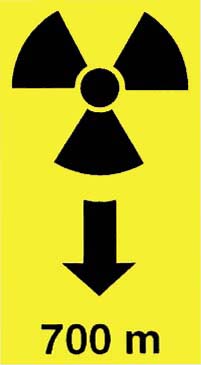
We decided against a large radiation symbol prominently displayed on a marker lest the potential intruders take a quick reading, find nothing more than background radiation, and ignore the rest of the message. We did decide that the incorporation of a radiation symbol was approriate within the larger context of the message. As a symbol, it could provide a link between textual and pictorial information.
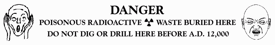
We decided against simple "Keep Out" messages with scary faces. Museums and private collections abound with such guardian figures removed from burial sites. These earlier warning messages did not work because the intruder knew that the burial goods were valuable. We did decide to include faces portraying horror and sickness (see Sections 3.3 and 4.5.1). Such faces would relate to the potential intruder wishing to protect himself or herself, rather than to protect a valued resource from thievery.
We decided against overstatement of the danger. The "Touch one stone and you will die" approach is unacceptable because it is not credible. Inevitably, someone will investigate the site in a non-intrusive manner. Nothing will happen to the person, and the rest of the message will therefore be ignored. There was consensus, however, on the need to mark the site and on the need to convey the dangers to the potential intruder.
We consider the key to a successful system to be a credible conveyance of the dangers of disturbing the repository. We must inform potential intruders what lies below and the consequences of disturbing the waste. If they decide that the value of the metal component of the waste fas outweighs the risks of recovering the metal, the decision is their responsibility, not ours.
4. Criteria for a Marking System with Examples
4.1 Site design guidelines for a design of the entire site, so it is a major component of a system of messages
The Design Guidelines herein will be largely performance-based, that is, they describe how the design must perform, rather than what it must look like or be made of. These guidelines can, in turn, be used as criteria to evaluate designs. Because performance-based design guidelines do not describe the design, but rather what ht edesign must do, several alternative designs can be developed in response to the guidelines. We have developed designs using the design guidelines, both as a test of the utility of the guidelines and as an expression of the team's preferred solutions. Because all the designs cover the entire interment, and then some, we refer to them as "site designs." These designs are presented in Section 4.2.
In this discussion and then later in the descriptions of the designs that test these design guidelines we will use the expression "the Keep" to define an area whose size and shape is the "footprint" or the vertical projection on the site's surface of the final interment area. Our team's analysis suggests that the final footprint may be larger than currently shown because of both migration of radionuclides in the salt and future expansion.
The various site designs may be listed as follows:
- The site must be marked.
- All levels of message complexity should be located on-ste. Thus, communication vehicles for information at Levels I, II, III, and IV should be on the WIPP site and available to humans. As well, this team has developed specific message content for each level, presented later in Section 4.6.
- The design of the whole site itself is to be a major source of meaning, acting as a framework for other levels of communication, reinforcing and being reinforced by those other levels in a system of communication. The message that we believe can be communication non-linguistically (through the design of the whole site), using physical form as a "natural language," encompasses Level I and portions (faces showing horror and sickness) of Level II. Put into words, it would communicate something like the following:
- This place is a message... and part of a system of messages... pay attention to it!
- Sending this message was impotant to us. We considered ourselves to be a powerful culture.
- This place is not a place of honor...no highly esteemed deed is commemorated here... nothing valued is here.
- What is here is dangerous and repulsive to us. This message is a warning about danger.
- The danger is in a particular location... it increases toward a center... the center of danger is here... of a particular size and shape, and below us.
- The danger is still present, in your time, as it was in ours.
- The danger is to the body, and it can kill.
- The form of the danger is an emanation of energy.
- The danger is unleashed only if you substantially disturb this place physically. This place is best shunned and left uninhabited.
- All physical site interventions and markings must be understood as communicating a message. It is not enough to know that this is a place of importance and danger...you must know that the place itself is a message, that it contains messages, and is part of a system of messages, and is a system with redundance.
- Redundancy of message communication is important to message survivability. Redundancy should be achieved through: (a) a high frequency of message locations, permitting some to be lost; (b) making direct and physical links among message levels, that is "co-presentation" of messages; and (c) multiple and mutually reinforcing modes of communication.
It is expected that the number of presentations of messages will decrease as the message complexity (or Level) increases. Thus, there will be many more presentations of Level II liquistic messages than of Level IV.
While the system of marking should strongly embody the principles of redundancy, at the same time the methods of achieving redundancy should be carefully designed to maintain message clarity. Redundancy should not be achieved at the expense of clarity.
- The method of site-marking must be very powerful to distinguish this place from all other types of places, so that the future must pay attention to this site. The place's physical structure should strongly suggest enhanced attention to itself and to its subelements. To achieve this, the volume of human effort used to make and mark this place must be understood as massive, emphasizing its importance to us. The site's constructions must be seen as an effort at the scale of a grand and committed culture, far beyond what a group or sect or organization could do.
About scale: "Scale" refers to the perceived size relationship between a human and something (like a house or a chair or a site). When the size of a thing gets far larger than a person, changes in scale are not easily perceived or are experienced as irrelevant. Thus, there is little difference to a person at ground level whether an earthwork is 1 mile or 2 miles long. These distances are experienced as much the same. What we propose as a marking for this site is already at a scale where it could be somewhat smaller or larger with no loss of meaning. And further, if the design were to be replicated elsewhere, it could be (somewhat) scaled up or down with no loss of meaning.
- Vertical masonry markers alone are simply not enough to accomplish our purposes. They are not large enough, nor frequent enough, nor sufficiently distinguishing from other sites already so marked; and their use elsewhere may well make their use here somewhat trivial and certainly ambguous. If only markers are used here, they will be seen as much like markers on other sites, which are generally sites of far less import, and also tend to be marked because they are honorific or commemorative, the opposite of the message we seek to send.
- Use a system of markeings that utilizes the whole site as an enormous mark, and that includes: smaller markers; high points to climb from which to view the entire site; walls and places to be in that co-locate viewers with messaegs...an organized environment. Consider the possible retention of a currently existing structure for symbolic purposes only, as a decaying massiveness.
As for use of existing-ste structures, if we assume no active institutional control, the only current above-ground site structure that might endure for a substantial portion of the 10,000 years would be the thick-walled concrete "hot" cell. The other buildings will decay, or more probably be stripped of their valuable building materials for re-use.
The "hot" cell may be put to symbolic use by incorporating it into the site's design, as a mute artifact suggesting something "strong" that needed to be contained, although from its large door size, a thing that had to be easily accessible and thus was (probably) not treasure. And because the "hot" cell's openings are randomly placed, rather than symmetrical, it would tend not to be mistaken for an honorific or privileged structure. If the "hot" cell is kept, it should not be located in the geometric center of any open space, which would symbolically elevate its importance.
While this system of markings should represent an enormous effort and investment of resources on our part, the construction itself should be of materials of little value, and the workmanship should not bestow any value through the elegance of craft or artistry. Doing substantial work on materials of little value suggests that the place is not commemorative of phenomena highly valued by the culture that made it, but as marking something important yet quite unvalued... not a treasure, but its opposite... a location of highly devalued material ("dangerous garbage" or an "un-treasure").
The place should not suggest shelter, protection or nurture... it should suggest that it is not a place for dwelling, nor for farming or husbandry. This would be most strongly communicated if the place obviously tries to deny inhabitation and utilization. It might best be designed as a place difficult to be in, and to work in...both actually and symbolically. Given this, the center of the place should reject rather than embrace. Any attractive focus on/near that center would suggest welcome, and by extension, occupancy and utilization.
We believe there is no physical barrier we can devise that (some) future technology cannot breach, and any attempt to bar entry physically to the Keep can and will be breached (by cutting through it, going under it, or coming down from above). Thus, any "barrier" placed around the Keep can only be purely symbolic, and should be used to enclose it only in a spatial sense rather than to attempt a fortification or a security barrier.
As to the meaning of "center": physically to mark the WIPP site in any way makes it a different place from the surrounding desert, and creates a "figure" against a "ground." It makes a center in the desert.
For human beginnings, making a center ("here we are") is the first act of marking order (Cosmos) out of undifferentiation (Chaos). All further meanings of "center" derive from this original positive valence. The meanings of "center" have always been as a highly valued place or a gathering place...the holy of holies; the statue centered within the temple, itself centered within the settlement; the dancing ground; the sacred place as the physical and spiritual center of a people, etc. In this project, we want to invert this symbolic meaning, to suggest that the center is not a place of privilege, or honor, or value, but its opposite. In symbolic terms, we suggest that the largest portion of the Keep, its center, be left open, and few (if any) structures placed there, so that symbolically it is: uninhabitated, shunned, a void, a hole, a non-place.
As for the geometric center, placement of anything at dead-center of the Keep would suggest that it is of the utmost importance, occupying the place of greatest privilege. We do not believe there is any one thing that can or should play that role on this site. (For example, someone might suggest that the highest Level IV of information might be placed at the center. But because a Level IV message may be gibberish to some intruders, while a Level II message would be well understood, no level of message is more important than any other, and no particular message or level is important enough to occupy the most privileged location.)
Design of the entire site and its subelements should avoid those forms that humans regularly tend to use to represent the "ideal," "perfection," or "aspiration." Aspiring forms are sky-reaching verticals, the obelisk, for example. Ideal and perfect ones are the the perfect forms of symmetrical geometry (spheres, pyramids, hexagons) and of regular crystalline structures or polyhedrons. If such forms are used, we suggest their perfection be undermined through substantial and obviously meant "irregularity," as if its builders knew about the ideal and perfection, but asserted that this place is not about them. More appropriate types of forms to use are amorphic or jagged and horizontal, a deliberate shunning of the values of "perfection" or "aspiration."
A major site-delivered message is that this place is ominous, not to be disturbed. This Level II message can be delivered both through site design and through "reading walls," discussed later. Message levels will probably be delivered in a sequence, but no level of message is more valuable than another. The design should incorporate this parity of levels. While Level IV information is certainly the most complete and detailed of all our communications at the site, there are certainly plausible future scenarios under which it will be of less value than a Level II message, or even of no value at all, even if seen. Thus, Level IV is more complex, but not a more valuable message to us (or future people), and its location should symbolically bestow no more value or privilege on it than on other message levels.
The design should provide a general sense of the magnitude, shape, and location of the original danger. Because there is no apparent danger at the site's surface, the design makes it clear that the danger is below and threatens to escape. The site design should also articulate that the dangerous material is bounded, has a substantial footprint that is of a certain shape. Going out from this on-surface imprint might be concentric bands designed to signify diminishing danger. It is not necessary to mark the Land Withdrawal boundary; it is a legal boundary that will be meaningless in a few centuries.
The enormity of the site's undertaking and its shape should be visible and comprehendible in its entirety, as a panorama. A panorama, the "seeing-all" from an altitude, is an ancient human metaphor for knowing, and seeking it is natural. Thus, provide elevated points for site viewing (mound, ziggurat, tower...all of which can be climbed for viewing).
The site-marking system should also function as a locator for multiple concepts of location and should:
- locate the site in relation to local centers of population of our time (which may contain archives as part of the information system);
- locate this site in relationship to other disposal sites in the world;
- locate the viewer ("you are here") on all three spatial axes in relationship to the entire site and its subelements, and to the hazard;
- locate the construction of this site in time; locate all on-site position of Level III and IV messages.
4.2 Design options
Presented here are several alternative designs for the entire site, followed by designs for some particular spaces on it. These designs are based on the Design Guidelines just presented and thus act as tests of the efficacy of the guidelines. Of the many designs developed and reviewed, these are also the design solutions most preferred by the team. The designs utilize archetypical images whose physical forms embody and communicate meaning. We have given them names, both for identification and as verbal images for each. They are:
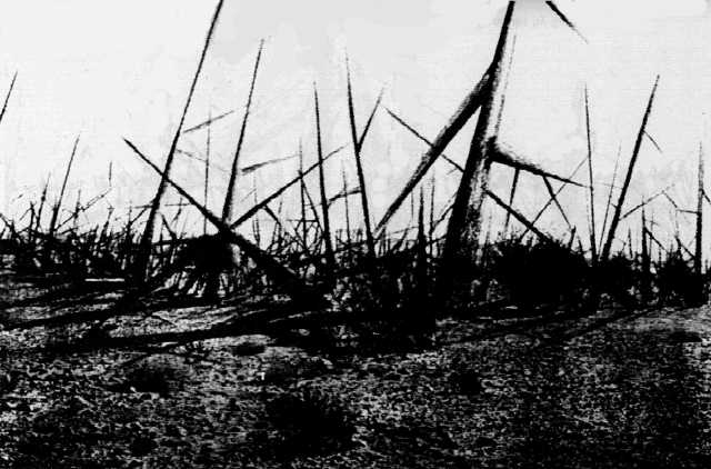
- Landscape of Thorns
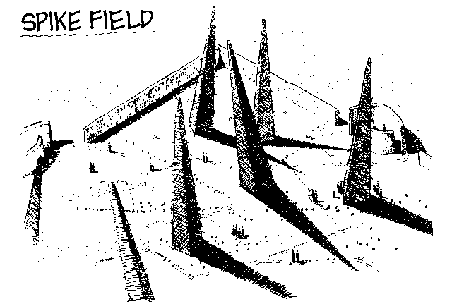
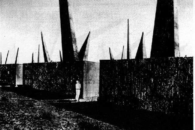
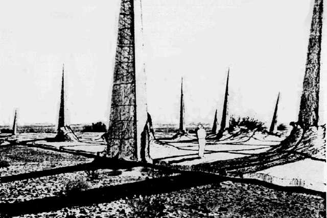
- Spike Field
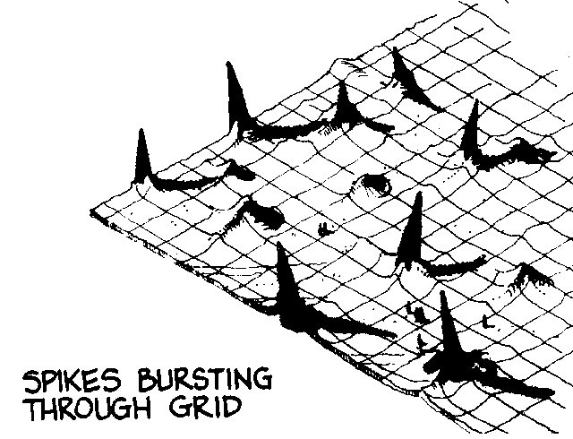
- Spikes Bursting Through Grid
- Leaning Stone Spikes
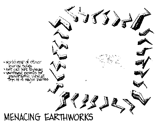
- Menacing Earthworks
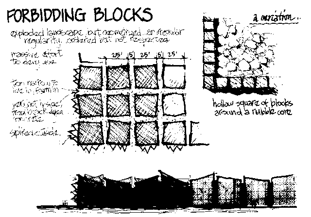
- Forbidding Blocks
Some designs use images of dangerous emanations and wounding of the body. Some are images of shunned land...land that is poisoned, destroyed, parched, uninhabitable, unusable. Some combine these images. All designs entirely cover or define at least the interment area, called here the Keep.
Shunned land...poisoned, destroyed, unusable:
"Black Hole": A masonry slab, either of black Basalt rock,or black-dyed concrete, is an image of an enormous black hole; an immense nothing; a void; land removed from use with nothing left behind; a useless place. It both looks uninhabitable and unfarmable, and it is, for it is exceedingly hot part of the year. Its blackness absorbs the desert's high sun-heat load and radiates it back. It is a massive effort to make a place that is fearful, ugly, and uncomfortable.
The heat of this black slab will generate substantial thermal movement. It should have thick expansion joints in a pattern that is irregular, like a crazy-quilt, like the cracks in parched land. And the surface of the slab should undulate so as to shed sand in patterns in the direction of the wind.
"Rubble Landscape": A square outer rim of the caliche layer of stone is dynamited and bulldozed into a crude square pile over the entire Keep. This makes a rubble-stone landscape at a level above the surrounding desert, an anomaly both topographic and in roughness of material. The outer rim from which rubble was pushed inward fills with sand, becoming a soft moat, probably with an anomalous pattern of vegetation. This all makes for an enormous landscape of large-stone rubble, one that is very inhospitable, being hard to walk on and difficult to bring machinery onto. It is a place that feels destroyed, rather than one that has been made.
Shapes that hurt the body and shapes that communicate danger:
Danger seems to emanate from below, and out of the Keep in the form of stone spikes (in Spike Field, Spikes Bursting Through Grid, and Leaning Stone Spikes), concrete thorns (in Landscape of Thorns), and zig-zag earthworks emanating from the Keep (in Menacing Earthworks). The shapes suggest danger to the body...wounding forms, like thorns and spikes, even lightning. They seem active, in motion out and up, moving in various directions. They are irregular or non-repetitive in their shape, location and direction. They seem not controlled, somewhat chaotic. In the three designs that use "fields" of spikes or thorns, these spikes or thorns come out of, and define the Keep, so the whole area that is dangerous to drill down into is so marked.
Figure 4.3-3. Spike Field, view 1 (concept and art by Michael Brill).
(Image is link to larger version.)
Figure 4.3-4. Spike Field, view 2 (concept by Michael Brill and art by Safdar Abidi).
(Image is link to larger version.)
Figure 4.3-5. Spikes Bursting Through Grid, view 1 (concept and art by Michael Brill).
(Image is link to larger version.)
Figure 4.3-6. Spikes Bursting Through Grid, view 2 (concept by Michael Brill and art by Safdar Abidi).
(Image is link to larger version.)
Figure 4.3-1. Landscape of Thorns (concept by Michael Brill and art by Safdar Abidi).
(Image is link to larger version.)
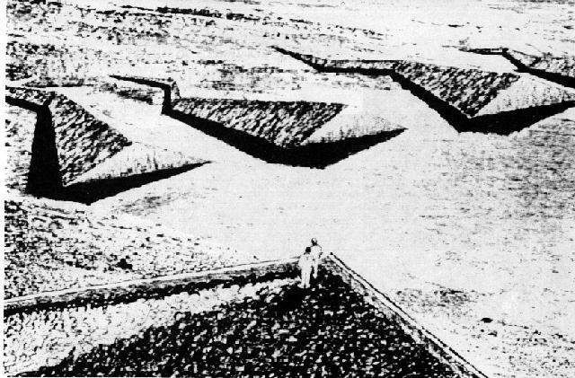
Figure 4.3-8. Menacing Earthworks, view 1 (concept and art by Michael Brill). [option recommended by Team A]
(Image is link to larger version.)
"Menacing Earthworks": Immense lightning-shaped earthworks radiating out of an open-centered Keep. It is very powerful when seen both from the air and from the vantage points on the tops of the four highest earthworks, the ones just off the corners of the square Keep. Walking through it, at ground level, the massive earthworks crowd in on you, dwarfing you, cutting off your sight to the horizon, a loss of connection to any sense of place.
Figure 4.3-9. Menacing Earthworks, view 2 (concept by Michael Brill and art by Safdar Abidi). [option recommended by Team A]
(Image is link to larger version.)
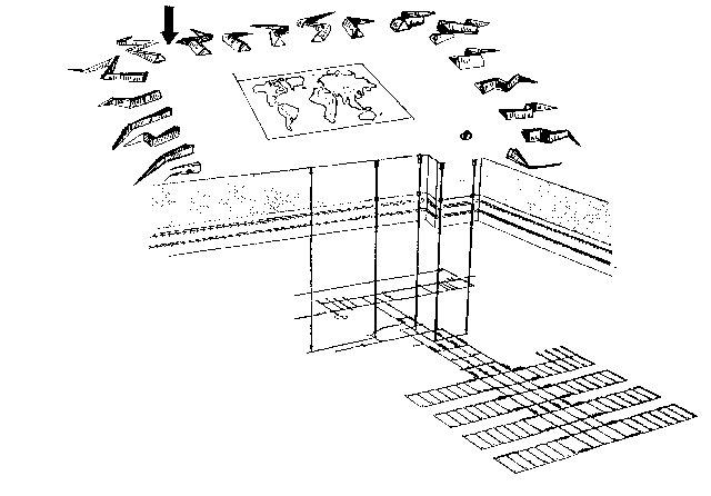
The large expanse of center is left open, with only two elements in it: the WIPP's existing thick-walled concrete hot cell, left to ruin; a walk-on world map showing locations of all the repositories of radioactive waste on earth and a 50-foot wide map of New Mexico with the WIPP site in the geometric center of the Keep. The entire map is domed in order to shed sand blown by the wind. Underneath the slightly domed map a Level 4 room is buried. Four other rooms are located under the four tallest earthworks. Reading walls are strewn between the earthworks, encountered before the Keep is entered.
Figure 4.5-7. A perspective view of the repository for Level III messages showing waste panels, shafts, marker features, and the reader's present location on the surface (arrow).
(Image is link to larger version.)
Figure 4.3-14. Forbidding Blocks, view 1 (concept and art by Michael Brill).
(Image is link to larger version.)
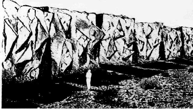
"Forbidding Blocks": Stone from the outer rim of an enormous square is dynamited and then cast into large concrete/stone blocks, dyed black. Each is about 25 feet on a side. They are deliberately irregular and distorted cubes. The cubic blocks are set in a grid, defining a square, with 5-foot wide "streets" running both ways. You can even get "in" it, but the streets lead nowhere, and they are too narrow to live in, farm in, or even meet in. It is a massive effort to deny use. At certain seasons it is very, very hot inside because of the black masonry's absorption of the desert's high sun-heat load. It is an ordered place, but crude in form, forbidding, and uncomfortable.
Figure 4.3-15. Forbidding Blocks, view 2 (concept by Michael Brill and art by Safdar Abidi).
(Image is link to larger version.)
Some blocks can be of granite, or faced with it, and carry inscriptions. Their closeness to other blocks reduces their exposure and increases their durability.
Note our use of irregular geometries and denial of craftsmanship. None of our designs uses any of the regular or "ideal" geometric forms, and only crude craftsmanship is sought, except for the precision of engraved messages. Why? the geometry of ideal forms, like squares and cubes, circles and spheres, triangles and pyramids is a fundamental human invention, a seeking of perfection in an imperfect world. Historically, people have used these ideal forms in places that embody their aspirations and ideals. In our designs, there is much iregularity both of forms and in their locations and directions, yet done by people with obvious knowledge of pure geometry. This shows as understanding of the ideal, but at the same time a deliberate shunning of it...suggesting we do not value this place, that it is not one that embodies our ideals.
The same is true of craft and workmanship. Historically, people use good workmanship to bestow value on things they value. In most of our schemes, the structures that cover or define the Keep's "cover" are made crudely, or of materials that prohibit workmanship (such as rubble, or earthworks, or a large slab). At the same time, we make an enormous investment of labor in these rude materials. It speaks of a massive investment, but one not tinged with pride or honored with value-through-workmanship.
About durability:
All the designs, except one, have a high probability of lasting 10,000 years. This is because of their conformity with the guidelines for materials durability in Section 4.4.
The concrete structures of the Landscape of Thorns have projecting, cantilevered elements that will have tension in their upper surfaces, causing minute cracks. These cracks will accelerate local decay. Until new materials are available, or new methods for tensioning concrete members [are found], we cannot "guarantee" the durability of this design. However, we present it here because of its strong emotive character.
5. Conclusions
5.2 The enormity of marking the WIPP site (FN)
If the WIPP is ever operational, the site may pose a greater hazard than is officially acknowledged. Yet the problems involved in marking the site to deter inadvertent intrusion for the next 10,000 years are enormous. Even if knowledge exists that would allow translation of the message on the markers, there might be little motivation to solicit such knowledge. Pictorial messages, however, are unreliable and may even convey the opposite of what is intended.
This panel member therefore recommends that the markers and the structures associated with them be conceived along truly gargantuan lines. To put their size into perspective, a simple berm, say 35-m wide and 15-m high, surrounding the proposed land-withdrawal boundary, would involve excavation, transport, and placement of around 12 million cubic meters of earth. What is proposed, of course, is on a much greater scale than that. By contrast, in the construction of the Panama Canal, 72.6 million cubic meters were excavated, and the Great Pyramid occupies 2.4 million cubic meters. In short, to ensure the probability of success, the WIPP marker undertaking will have to be one of the greatest public works ventures in history.
5.3 Personal thoughts (WS)
Working on this panel, always fascinating and usually enlightening too, has led to the following personal thoughts:
- We have all become very marker-prone, but shouldn't we nevertheless admit that, in the end, despite all we try to do, the most effective "marker" for any intruders will be a relatively limited amount of sickness and death caused by the radioactive waste? In other words, it is largely a self-correcting process if anyone intrudes without appropriate precautions, and it seems unlikely that intrusion on such buried waste would lead to large-scale disasters. An analysis of the likely number of deaths over 10,000 years due to inadvertent intrusion should be conducted. This cost should be weighted against that of the marker system.
- The design and testing of markers and messages must involve a broad spectrum of societies and people within those societies. So-called "experts" can of course make important contributions, but they must listen carefully to all other people who represent those who might encounter the markers. In the course of working on this project, I received excellent ideas from a wide range of undergraduates, colleagues, friends, and relatives.
- The very exercise of designing, building, and viewing the markers creates a powerful testimony addressed to today's society about the full environmental, social, and economic costs of using nuclear materials. We can never know if we indeed have successfully communicated with our descendants 400 generations removed, but we can, in any case, perhaps convey an important message to ourselves.
5.6 "Beauty is conserved, ugliness discarded" (DGA)
To design a marker system that, left alone, will survive for 10,000 years is not a difficult engineering task.
It is quite another matter to design a marker system that will for the next 400 generations resist attempts by individuals, organized groups, and societies to destroy or remove the markers. While this report discusses some strategies to discourage vandalism and recycling of materials, we cannot anticipate what people, groups, societies may do with the markers many millennia from now.
A marker system should be chosen that instills awe, pride, and admiration, as it is these feelings that motivate people to maintain ancient markers, monuments, and buildings.
See Also
Permant Markers Implementation Plan (August 19, 2004) - the follow-up to this document, sadly not including any of the exotic design options from this document.
The Waste Isolation Pilot Plant Information Server - The official WIPP home page gas all the information and latest news on WIPP.
LA Times story (May 3, 2006) about the markings. (Thanks, Fark!)